△ TruthInStone

Sites › North America › El Mirador and the Mirador-Calakmul Karst Basin

El Mirador and the Mirador-Calakmul Karst Basin

El Mirador and the Mirador-Calakmul Karst Basin
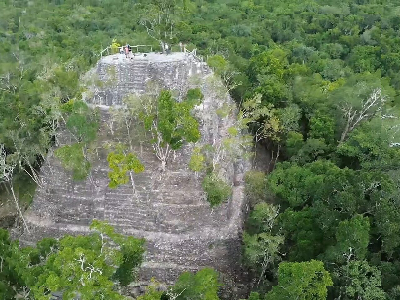
Image: Konjiki1, Wikimedia Commons, CC0. Resized; not otherwise altered. All credits.
📍 Where It Is Petén Jungle, northern Guatemala & Campeche, Mexico 17.7550°, -89.9206°
🏛️ Mainstream Date c. 1000 BCE to 150 CE (Preclassic Maya peak at El Mirador) Excavated baseline
🧭 Leading Edge / Open Angle 2.8-million-m³ La Danta pyramid & 1,000+ km of laser-mapped roads Debated or newly revised
🪨 Heaviest Stone & Quarry 2.8 million m³ total volume at La Danta (blocks up to ~5 tons) 0.1× the 40-ton test limit · Compare all 64 sites →
30-SECOND TAKEAWAY

In Plain English — The 30-Second Takeaway

What It Is:

El Mirador. Also, the Mirador-Calakmul basin in Guatemala hold the largest Preclassic Maya pyramids and a jungle-wide network of raised stone highways.

What Everyone Agrees On (Measured Facts):

La Danta pyramid rises 72 meters with a total platform volume of 2.8 million cubic meters. LiDAR mapped over 1,000 km of white-plastered causeways.

🏛️ Mainstream Archaeology View:

Scholars date El Mirador's boom between 600 BCE and 150 CE, centuries before Classic Maya cities like Tikal peaked.

🧭 Leading Edge View:

The laser maps reveal a unified regional road and canal system connecting over 400 towns beneath the Petén rainforest.

Site Story & Overview

The causeway network suggests regional group centuries before the Classic Maya kingdoms. One caution comes from the paper itself: many site dates come from archaeological test pits plus comparisons of building volume and form, not from excavation at every site. The image shows La Danta, one of the largest structures at El Mirador.

✓ What Is Physically Measured on Site

Dated samples, laser scans, stone weights, and dug finds kept separate from opinion.

🏛️ Mainstream Archaeological View

  • Accepted timeline: Preclassic Maya, about 1000 BCE–150 CE. El Mirador peaked in the Late Preclassic.
  • Stone & hardness: Karstic limestone & sascab mortar — Mohs hardness 3.5 (Limestone) (on the 1–10 Mohs scale where a steel knife is ~5.5 and diamond is 10).
  • Quarry distance & alignment: Stone source 0.5–2 km (adjacent bajo quarries). Orientation: East–west triadic acropolis & astronomical E-Group axes.

🧭 Leading Edge Proposal & Open Questions

  • Timeline consensus: The laser maps reveal a unified regional road and canal system connecting over 400 towns beneath the Petén rainforest.
  • Engineering comparison: Heaviest unit is 2.8 million m³ total volume at La Danta (72 m high; blocks up to ~5 t) (0.5–2 km (adjacent bajo quarries)). See how it compares in our 64-Site Scale-Gap Explorer.

Tested Claims About El Mirador and the Mirador-Calakmul Karst Basin

ClaimStatusVerdict
LiDAR shows Maya lowlands were far more densely settled than thought
Airplane laser scans have revealed tens of thousands of hidden Maya buildings, roads, and farms under the jungle.
MainstreamMeasured: far denser settlement than mapped before

Visiting & base stays: El Mirador (La Danta) & Mirador-Calakmul Basin (Flores, Petén base, Guatemala)

FTC affiliate disclosure: Tour links go to GetYourGuide and Viator. Hotel links use Stay22 (aid=solarevidence) for Booking.com and Expedia. If you book a trip, we may earn a small fee at no extra cost to you. All partner links use rel="sponsored nofollow noopener". Check travel alerts before you go. Partner fees never change our ratings. All 64 site field visits · Affiliate disclosure.

📚 Further Reading: Both Sides of the Argument

Top books from both sides of the debate on this topic. Browse all 34 books on Books & Further Reading or visit our Search for the Truth Bookshop.org storefront.

Mainstream Baseline 2022 ★ 4.7/5

The Maya (10th ed.)

Michael D. Coe & Stephen Houston

The classic guide to the Maya world, updated with new jungle laser maps, the 1000 BCE Aguada Fénix platform, and calendar science.

▸ Why this book matters to both sides

The tenth edition of the standard academic overview of Maya culture, updated with airborne LiDAR surveys across the Petén and Campeche, the 1000 BCE Aguada Fénix plateau, and Long Count astronomy.

Role in the debate: Pairs the latest LiDAR town densities and epigraphic readings with Mesoamerican calendrical and sky debates. (ISBN 9780500295144)

Mainstream Baseline 2019 ★ 4.4/5 · AIA Holton Award

Archaeology from Space: How the Future Shapes Our Past

Sarah Parcak

Explains how satellites and airplane lasers spot buried cities, roads, and temples across Egypt and the Americas.

▸ Why this book matters to both sides

Remote-sensing archaeologist Sarah Parcak explains how multispectral satellite imagery and airborne LiDAR reveal buried towns, road networks, and giant foundations across Egypt, Europe, and the Americas.

Role in the debate: Explains the physics and ground-truthing requirements of remote sensing—essential context for comparing verified LiDAR cities against disputed subsurface radar claims. (ISBN 9781250231345)

Mainstream Baseline 2005 ★ 4.6/5

1491: New Revelations of the Americas Before Columbus (2nd ed.)

Charles C. Mann

Shows how new digs and laser maps proved the ancient Americas held big cities, roads, and farms long before Columbus.

▸ Why this book matters to both sides

Surveys the archaeological, botanical, and demographic discoveries showing that the pre-Columbian Americas—from Caral-Supe and the Amazon basin to Cahokia—were older, more populous, and more engineered than once taught.

Role in the debate: Documents how mainstream field evidence overturned the 20th-century 'pristine wilderness' model in the Amazon and pushed giant buildings in Peru back to the third millennium BCE. (ISBN 9781400032051)

Leading Edge 2019 ★ 4.7/5

America Before: The Key to Earth's Lost Civilization

Graham Hancock

Explores Amazon earthworks, Serpent Mound, ancient DNA, and early American sites to argue for an Ice Age culture in the Americas.

▸ Why this book matters to both sides

Tests pre-Clovis archaeological sites, Ancient North Eurasian DNA signals, Amazonian earthworks, Serpent Mound, and Poverty Point. It argues the Americas were central to an Ice Age cultural network.

Role in the debate: Contrasts directly with Charles Mann's *1491* and mainstream Americanist archaeology on early peopling, Amazon geoglyphs, and North American earthen mounds. (ISBN 9781250756954)

FTC affiliate disclosure: Book links go to Bookshop.org (ID 130218, Search for the Truth). Each sale helps local bookstores and pays us a 10% fee at no extra cost to you. All partner links use rel="sponsored nofollow noopener". Fees never change our verdicts. Affiliate disclosure.

Primary Academic Sources

▸ View All Cited Primary Sources & DOIs (2 papers)
  1. Hansen, R. D. et al. (2022). LiDAR analyses in the contiguous Mirador-Calakmul Karst Basin, Guatemala. Ancient Mesoamerica. doi:10.1017/S0956536122000244 data
  2. Ensley, S. et al. (2021). Geomorphology of the Mirador-Calakmul Karst Basin: a GIS-based approach to hydrogeologic mapping. PLOS ONE 16. doi:10.1371/journal.pone.0255496 data

Dates and stone checks are summed up in plain English from the papers above. Measured facts stay separate from opinion. Methodology.