△ TruthInStone

Sites › Asia › The 1513 Piri Reis World Map (Topkapı Palace, Istanbul)

The 1513 Piri Reis World Map (Topkapı Palace, Istanbul)

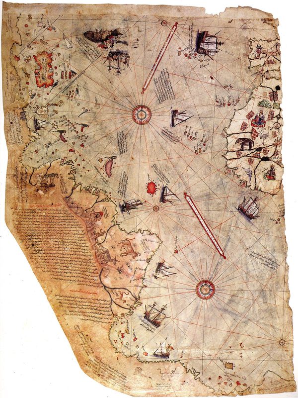
The 1513 Piri Reis World Map (Topkapı Palace, Istanbul)
Image: Piri Reis (1513 CE Ottoman portolan chart, Topkapı Palace Museum), Wikimedia Commons, Public domain. Resized; not otherwise altered. All credits.
📍 Where It Is Topkapı Palace Library, Istanbul, Türkiye (Near East & Anatolia) 41.0115°, 28.9834°
🏛️ Mainstream Date 1513 CE (AH 919) Ottoman chart from Portuguese & Columbus maps Excavated baseline
🧭 Leading Edge / Open Angle Charles Hapgood (1966) proposed an ice-free Antarctica source map Debated or newly revised
🪨 Heaviest Stone & Quarry 90 × 63 cm gazelle parchment chart (20+ Ottoman Turkish notes) 0.0× the 40-ton test limit · Compare all 64 sites →
30-SECOND TAKEAWAY

In Plain English — The 30-Second Takeaway

What It Is:

The Piri Reis Map is a 1513 Ottoman world sea chart drawn on gazelle skin by Admiral Piri Reis. It was found at Topkapı Palace in 1929.

What Everyone Agrees On (Measured Facts):

The 35-by-25-inch parchment shows the Atlantic coasts of Europe, Africa, and South America. Piri Reis wrote that he combined 20 older maps, including one by Columbus.

🏛️ Mainstream Archaeology View:

Map historians show the bottom coastline bends South America eastward to fit the animal skin, using real Portuguese Brazilian place-names from 1500 to 1511.

🧭 Leading Edge View:

In 1966, Charles Hapgood argued the bottom coast matches Queen Maud Land in Antarctica. He suggested Ice Age mariners mapped the land before it froze.

Site Story & Overview

On October 9, 1929, scholars at Topkapı Palace in Istanbul opened a bundle of old maps. Inside, they found a colorful 1513 sea chart of the Atlantic Ocean.

▸ Read Full Archaeological & Engineering Context

Drawn on gazelle skin in 1513 CE at Gallipoli by Ottoman naval captain and cartographer Piri Reis (c. 1470–1553), the surviving fragment preserves the western third of a world map. Its 20+ Ottoman Turkish notes credit a captured chart from Christopher Columbus's Caribbean voyages alongside four Portuguese charts and classical Ptolemaic maps. In 1966, historian Charles Hapgood proposed in Maps of the Ancient Sea Kings that the map's bottom coastline traced Queen Maud Land in Antarctica before it froze over. Cartographic historian Gregory McIntosh (2000) tested every place-name and coastline bend against 16th-century Portuguese portolans.

✓ What Is Physically Measured on Site

Dated samples, laser scans, stone weights, and dug finds kept separate from opinion.

🏛️ Mainstream Archaeological View

  • Accepted timeline: Ottoman world portolan chart drawn on gazelle skin in 1513 CE (AH 919) by Admiral Piri Reis in Gallipoli, compiled from 20 named source charts (including Portuguese South American charts from 1500–1511 and a captured 1490s chart of Christopher Columbus).
  • Stone & hardness: Gazelle skin parchment with iron-gall & polychrome pigments (Topkapı Palace) — Mohs hardness 1.5 (Parchment manuscript in Topkapı Palace) (on the 1–10 Mohs scale where a steel knife is ~5.5 and diamond is 10).
  • Quarry distance & alignment: Stone source Drawn in Gallipoli (1513 CE) from 20 source charts; housed 220 km away at Topkapı Palace. Orientation: 32-point portolan wind-rose rhumb-line network across the Atlantic Ocean.

🧭 Leading Edge Proposal & Open Questions

  • Arlington Mallery (1956) & Charles Hapgood (Maps of the Ancient Sea Kings, 1966): Ice-free Antarctica source map: Argued that the rightward-bending coastline at the bottom of the 1513 map depicts Queen Maud Land in Antarctica mapped before its ice cap formed, using spherical trigonometry inherited from a pre-classical seafaring culture. [3][5]

Tested Claims About The 1513 Piri Reis World Map (Topkapı Palace, Istanbul)

ClaimStatusVerdict
An advanced civilisation existed during the last Ice Age and was lost in a catastrophe
Did an advanced seafaring culture exist during the Ice Age before floods and impacts destroyed it 12,000 years ago?
Leading EdgeOpen question
The 1513 Piri Reis map depicts Antarctica's Queen Maud Land coastline before it was covered by ice
Does Admiral Piri Reis's 1513 world map show Antarctica's Queen Maud Land coast before ice covered it?
Leading EdgeMeasured: the 1513 parchment names 20 source charts (including Columbus and 4 Portuguese charts) and carries 1500–1511 Portuguese Brazilian place-names along the bent bottom coast; Antarctic ice cores show Queen Maud Land has been glaciated for millions of years

Visiting & base stays: Topkapı Palace Museum & Library (1513 Piri Reis Map Archive, Sultanahmet, Istanbul)

FTC affiliate disclosure: Tour links go to GetYourGuide and Viator. Hotel links use Stay22 (aid=solarevidence) for Booking.com and Expedia. If you book a trip, we may earn a small fee at no extra cost to you. All partner links use rel="sponsored nofollow noopener". Check travel alerts before you go. Partner fees never change our ratings. All 64 site field visits · Affiliate disclosure.

📚 Further Reading: Both Sides of the Argument

Top books from both sides of the debate on this topic. Browse all 34 books on Books & Further Reading or visit our Search for the Truth Bookshop.org storefront.

Mainstream Baseline 2005 ★ 4.6/5

1491: New Revelations of the Americas Before Columbus (2nd ed.)

Charles C. Mann

Shows how new digs and laser maps proved the ancient Americas held big cities, roads, and farms long before Columbus.

▸ Why this book matters to both sides

Surveys the archaeological, botanical, and demographic discoveries showing that the pre-Columbian Americas—from Caral-Supe and the Amazon basin to Cahokia—were older, more populous, and more engineered than once taught.

Role in the debate: Documents how mainstream field evidence overturned the 20th-century 'pristine wilderness' model in the Amazon and pushed giant buildings in Peru back to the third millennium BCE. (ISBN 9781400032051)

Mainstream Baseline 2004 ★ 4.4/5

The Long Summer: How Climate Changed Civilization

Brian Fagan

Explains how sudden climate flips—like the 1,200-year Younger Dryas freeze—shaped early human farming and towns.

▸ Why this book matters to both sides

Archaeologist Brian Fagan examines how the Younger Dryas cold reversal, Lake Agassiz meltwater releases, the 8.2 ka event, and mid-Holocene droughts shaped agriculture and ancient states.

Role in the debate: Sets out the standard ocean-circulation (AMOC shutdown) and ancient climate model of the Younger Dryas and its effects on Near Eastern and European societies. (ISBN 9780465022823)

Leading Edge 1966 ★ 4.6/5

Maps of the Ancient Sea Kings: Evidence of Advanced Civilization in the Ice Age

Charles H. Hapgood

Studies the 1513 Piri Reis map and old sea charts to argue they copy surveys made by Ice Age mariners.

▸ Why this book matters to both sides

Analyzes the 1513 Piri Reis map, the 1531 Oronteus Finaeus map, and medieval portolans with U.S. Air Force cartographers. It argues they preserve spherical trigonometrical surveys from an Ice Age seafaring culture.

Role in the debate: A foundational source for the lost-Ice-Age-culture and Antarctica cartography arguments cited by Hancock, Flem-Ath, and Schoch. (ISBN 9780932813428)

Leading Edge 1995 ★ 4.7/5

Fingerprints of the Gods: The Evidence of Earth's Lost Civilization

Graham Hancock

Graham Hancock's bestseller arguing that Giza, Pumapunku, and ancient maps preserve traces of a lost Ice Age culture.

▸ Why this book matters to both sides

Hancock's worldwide bestseller examining Tiwanaku, Pumapunku, Teotihuacan, Giza, the Piri Reis map, and Hapgood's crustal-shift model. It argues for an Ice Age culture lost in a global cataclysm.

Role in the debate: The book that brought the lost-Ice-Age-culture idea to millions of readers and framed the modern debate over Giza, Pumapunku, and ancient sky sightlines. (ISBN 9780517887295)

FTC affiliate disclosure: Book links go to Bookshop.org (ID 130218, Search for the Truth). Each sale helps local bookstores and pays us a 10% fee at no extra cost to you. All partner links use rel="sponsored nofollow noopener". Fees never change our verdicts. Affiliate disclosure.

Primary Academic Sources

▸ View All Cited Primary Sources & DOIs (5 papers)
  1. McIntosh, G. C. (2000). The Piri Reis Map of 1513. Athens, GA: University of Georgia Press. doi:10.1353/book21157 data
  2. Soucek, S. (1994). Piri Reis and Ottoman Discovery of the Great Discoveries. Studia Islamica 79: 129–142 (and 1996 Nour Foundation monograph). doi:10.2307/1595839 data
  3. Hapgood, C. H. (1966). Maps of the Ancient Sea Kings: Evidence of Advanced Civilization in the Ice Age. Chilton Books / Turnstone (Open Library record). https://openlibrary.org/works/OL4967536W proponent
  4. Zachos, J., Pagani, M., Sloan, L., Thomas, E. & Billups, K. (2001). Trends, rhythms, and aberrations in global climate 65 Ma to present (Antarctic ice sheet history). Science 292: 686–693. doi:10.1126/science.1059412 data
  5. Hancock, G. (1995). Fingerprints of the Gods. Heinemann / Crown. Chapter 49. https://openlibrary.org/search?q=fingerprints+of+the+gods+hancock proponent

Dates and stone checks are summed up in plain English from the papers above. Measured facts stay separate from opinion. Methodology.