△ TruthInStone

Sites › Asia › Angkor (Angkor Wat and Greater Angkor)

Angkor (Angkor Wat and Greater Angkor)

Angkor (Angkor Wat and Greater Angkor)
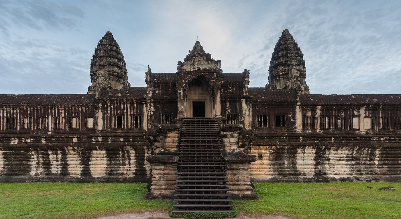
Image: Diego Delso, Wikimedia Commons, CC BY-SA 3.0. Resized; not otherwise altered. All credits.
📍 Where It Is Siem Reap Province, northwestern Cambodia 13.4125°, 103.8670°
🏛️ Mainstream Date c. 802–1431 CE (Angkor Wat built c. 1113–1150 CE) Excavated baseline
🧭 Leading Edge / Open Angle Debated 10,500 BCE Draco constellation layout vs. Khmer city grid Debated or newly revised
🪨 Heaviest Stone & Quarry 5–12 tons (sandstone blocks rafted ~35–40 km from Mount Kulen) 0.3× the 40-ton test limit · Compare all 64 sites →
30-SECOND TAKEAWAY

In Plain English — The 30-Second Takeaway

What It Is:

Angkor in Cambodia holds Angkor Wat at the center of a vast ancient-tool water city. Note: the largest religious site on Earth.

What Everyone Agrees On (Measured Facts):

Airborne laser scans. (2012–2015) mapped a planned street grid across 35 square km inside a 1,000-square-kilometer network of canals and giant reservoirs.

🏛️ Mainstream Archaeology View:

Inscriptions and carbon dates place Angkor Wat in the early 1100s CE under King Suryavarman II. It has stone floated by canal from Mount Kulen.

🧭 Leading Edge View:

Graham Hancock proposed in 1998 that the ground plan of Angkor's main temples mirrors the dragon constellation Draco as it looked in 10,500 BCE.

Site Story & Overview

The lidar work changed the picture of Angkor from temples in the forest to one of the largest ancient-tool urban landscapes. The authors say the lidar adds nothing new to the dates of the temples, which come from carved texts. UNESCO World Heritage Site since 1992.

✓ What Is Physically Measured on Site

Dated samples, laser scans, stone weights, and dug finds kept separate from opinion.

How carbon dates work, and their limits: How we date sites.

🏛️ Mainstream Archaeological View

  • Accepted timeline: Capitals of the Khmer Empire, 9th–15th centuries CE. Angkor Wat built in the early 12th century (dated by carved texts and building style).
  • Stone & hardness: Phnom Kulen feldspathic greywacke sandstone & porous laterite core — Mohs hardness 6.0 (Quartz-rich sandstone) (on the 1–10 Mohs scale where a steel knife is ~5.5 and diamond is 10).
  • Quarry distance & alignment: Stone source 35 km by canal from Phnom Kulen quarries. Orientation: Due West (~0.75° off true E–W; March equinox sunrise over central lotus tower).

🧭 Leading Edge Proposal & Open Questions

  • Graham Hancock (Heaven's Mirror, 1998): The layout of Angkor's main temples mirrors the constellation Draco as it stood about 10,500 BCE (an untested pattern match, not a building date) [5]

Tested Claims About Angkor (Angkor Wat and Greater Angkor)

ClaimStatusVerdict
Angkor's temples mirror the constellation Draco as it stood in 10,500 BCE
Were the temples of Angkor in Cambodia laid out to mirror the dragon constellation Draco in 10,500 BCE?
Leading EdgeMeasured sky: in 10,500 BCE Draco's head crossed the north meridian at its lowest at equinox dawn, but the same moment in Angkor's building era shows the figure turned about 170°, so the match depends on how the plan is read

Visiting & base stays: Angkor Wat, Angkor Thom & Greater Angkor Hydraulic City (Siem Reap, Cambodia)

FTC affiliate disclosure: Tour links go to GetYourGuide and Viator. Hotel links use Stay22 (aid=solarevidence) for Booking.com and Expedia. If you book a trip, we may earn a small fee at no extra cost to you. All partner links use rel="sponsored nofollow noopener". Check travel alerts before you go. Partner fees never change our ratings. All 64 site field visits · Affiliate disclosure.

📚 Further Reading: Both Sides of the Argument

Top books from both sides of the debate on this topic. Browse all 34 books on Books & Further Reading or visit our Search for the Truth Bookshop.org storefront.

Mainstream Baseline 2019 ★ 4.4/5 · AIA Holton Award

Archaeology from Space: How the Future Shapes Our Past

Sarah Parcak

Explains how satellites and airplane lasers spot buried cities, roads, and temples across Egypt and the Americas.

▸ Why this book matters to both sides

Remote-sensing archaeologist Sarah Parcak explains how multispectral satellite imagery and airborne LiDAR reveal buried towns, road networks, and giant foundations across Egypt, Europe, and the Americas.

Role in the debate: Explains the physics and ground-truthing requirements of remote sensing—essential context for comparing verified LiDAR cities against disputed subsurface radar claims. (ISBN 9781250231345)

Mainstream Baseline 2003 ★ 4.5/5

After the Ice: A Global Human History, 20,000–5000 BC

Steven Mithen

Follows human life across every continent from the peak of the Ice Age (20,000 BCE) to early farming towns (5000 BCE).

▸ Why this book matters to both sides

A continent-by-continent narrative of human life from the Last Glacial Maximum to 5000 BCE, built directly from excavation reports across the Near East (including Göbekli Tepe), Europe, Asia, and the Americas.

Role in the debate: Provides the archaeological baseline for what human populations were building, hunting, and cultivating before, during, and right after the Younger Dryas. (ISBN 9780674019997)

Leading Edge 1995 ★ 4.7/5

Fingerprints of the Gods: The Evidence of Earth's Lost Civilization

Graham Hancock

Graham Hancock's bestseller arguing that Giza, Pumapunku, and ancient maps preserve traces of a lost Ice Age culture.

▸ Why this book matters to both sides

Hancock's worldwide bestseller examining Tiwanaku, Pumapunku, Teotihuacan, Giza, the Piri Reis map, and Hapgood's crustal-shift model. It argues for an Ice Age culture lost in a global cataclysm.

Role in the debate: The book that brought the lost-Ice-Age-culture idea to millions of readers and framed the modern debate over Giza, Pumapunku, and ancient sky sightlines. (ISBN 9780517887295)

Bridge / Debate History 1969 ★ 4.6/5

Hamlet's Mill: An Essay Investigating the Origins of Human Knowledge and Its Transmissions Through Myth

Giorgio de Santillana & Hertha von Dechend

Two science historians argue that ancient stories worldwide preserve real observations of the 26,000-year wobble of the stars.

▸ Why this book matters to both sides

Written by historians of science at MIT and Frankfurt University. The author argues ancient stories worldwide encode technical findings of the 26,000-year sky wobble of the equinoxes and shifting world ages.

Role in the debate: The scholarly bridge between academic history of astronomy and modern sky-sightline claims about sky-cycle coding at Giza, Angkor, and Göbekli Tepe. (ISBN 9780879232153)

FTC affiliate disclosure: Book links go to Bookshop.org (ID 130218, Search for the Truth). Each sale helps local bookstores and pays us a 10% fee at no extra cost to you. All partner links use rel="sponsored nofollow noopener". Fees never change our verdicts. Affiliate disclosure.

Primary Academic Sources

▸ View All Cited Primary Sources & DOIs (6 papers)
  1. Evans, D. H. et al. (2013). Uncovering archaeological landscapes at Angkor using lidar. PNAS 110. doi:10.1073/pnas.1306539110 data
  2. Evans, D. (2016). Airborne laser scanning as a method for exploring long-term socio-ecological dynamics in Cambodia. Journal of Archaeological Science 74. doi:10.1016/j.jas.2016.05.009 data
  3. Chevance, J.-B., Evans, D. et al. (2019). Mahendraparvata: an early Angkor-period capital defined through airborne laser scanning at Phnom Kulen. Antiquity 93 (corrigendum 2020). doi:10.15184/aqy.2019.133 data
  4. UNESCO World Heritage Centre: Angkor (inscribed 1992). https://whc.unesco.org/en/list/668/ background
  5. Hancock, G. & Faiia, S. (1998). Heaven's Mirror. Part III, Cambodia (chapter 7, 'Draco'). Publisher's summary and contents on the author's site. https://grahamhancock.com/heavens-mirror/ proponent
  6. Truth in Stone (2026). Angkor–Draco precession check: Python script, released under CC0 1.0. /static/downloads/angkor-draco-precession.py data

Dates and stone checks are summed up in plain English from the papers above. Measured facts stay separate from opinion. Methodology.