△ TruthInStone

Sites › North America › Chichén Itzá (El Castillo) and Uxmal

Chichén Itzá (El Castillo) and Uxmal

Chichén Itzá (El Castillo) and Uxmal
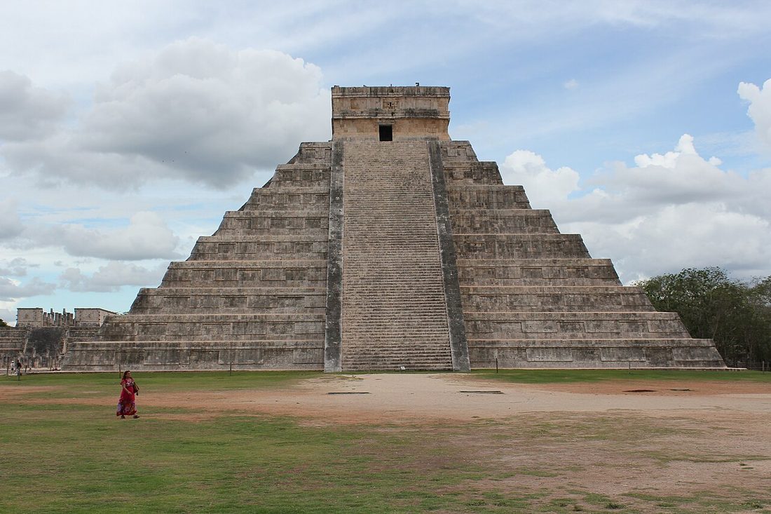
Image: Arian Zwegers from Brussels, Belgium, Wikimedia Commons, CC BY 2.0. Resized; not otherwise altered. All credits.
📍 Where It Is Northern Yucatán Peninsula, Mexico 20.6843°, -88.5678°
🏛️ Mainstream Date c. 600–1200 CE (El Castillo outer pyramid built c. 900–1000 CE) Excavated baseline
🧭 Leading Edge / Open Angle 3D scans found two inner pyramids over a hidden underground cavern Debated or newly revised
🪨 Heaviest Stone & Quarry 3–8 tons (carved serpent columns & lintels; 30-m pyramid over cenote) 0.2× the 40-ton test limit · Compare all 64 sites →
30-SECOND TAKEAWAY

In Plain English — The 30-Second Takeaway

What It Is:

Chichén Itzá and Uxmal are the giant limestone capitals of the northern Yucatán Maya, built over a landscape of underground sinkholes and cisterns.

What Everyone Agrees On (Measured Facts):

3D electrical scans in 2018 proved the 30-meter El Castillo pyramid contains two older nested pyramids sitting directly over a 20-meter-deep water cavern. Cenote.

🏛️ Mainstream Archaeology View:

Acoustic and solar studies confirm El Castillo's 365 steps align with zenith sunsets, equinox shadows. A staircase echo that mimics the sacred quetzal bird.

🧭 Leading Edge View:

Experts debate how much of the famous equinox serpent shadow comes from original Maya stone cutting versus 1920s archaeological rebuild.

Site Story & Overview

Chichén Itzá and Uxmal represent the pinnacle of northern Yucatán limestone building in a karst landscape with zero surface rivers. There, urban survival depended entirely on natural sinkholes (cenotes) at Chichén Itzá and hundreds of bottle-shaped underground plastered cisterns (chultunes) at Uxmal.

▸ Read Full Archaeological & Engineering Context

Recent 3D resistivity tomography under El Castillo confirmed that the pyramid stands at the intersection of four sacred cenotes (North/Sacred, Xtoloc, Holtún, and Kanjuyum) with a fifth water-filled cavity directly beneath the pyramid's core. Both complexes are inscribed as UNESCO World Heritage Sites.

✓ What Is Physically Measured on Site

Dated samples, laser scans, stone weights, and dug finds kept separate from opinion.

🏛️ Mainstream Archaeological View

  • Accepted timeline: Terminal Classic to Early Postclassic Maya centres: Uxmal flourished c. 600–1000 CE (Puuc style). Chichén Itzá peaked c. 600–1200 CE, with the outer El Castillo pyramid built c. 900–1000 CE over two older substructures.
  • Stone & hardness: Miocene-Pliocene Yucatán karstic limestone & lime concrete — Mohs hardness 3.5 (Karstic limestone) (on the 1–10 Mohs scale where a steel knife is ~5.5 and diamond is 10).
  • Quarry distance & alignment: Stone source 0.5–2 km (local surface limestone beds & sascab pits). Orientation: El Castillo 291.3° WNW zenith sunset & equinox serpent shadow; Uxmal Governor's Palace Venus extremum.

🧭 Leading Edge Proposal & Open Questions

  • Archaeoastronomical & acoustic researchers: Propose that El Castillo's 365 steps, equinox serpent-shadow descent, and quetzal-chirp staircase echo were intentionally engineered as an integrated solar-acoustic instrument. Critics debate how much of the shadow effect depends on 1920s–30s restoration choices [2][3]

Tested Claims About Chichén Itzá (El Castillo) and Uxmal

ClaimStatusVerdict
Pyramids around the world point to a common lost source
Did pyramids in Egypt, Peru, Mexico, Sudan. Also, China come from one shared ancient parent culture?
Leading EdgeOpen question
LiDAR shows Maya lowlands were far more densely settled than thought
Airplane laser scans have revealed tens of thousands of hidden Maya buildings, roads, and farms under the jungle.
MainstreamMeasured: far denser settlement than mapped before
Solar alignments & eclipse monuments: solstice, equinox and the August 2, 2027 total eclipse over Luxor & Karnak
This review covers ancient sites proven to track the Sun's solstices and equinoxes, plus the 2027 total eclipse over Egypt.
MainstreamMeasured: solar horizon alignments (solstice and equinox azimuths) at Chankillo, Stonehenge, Newgrange, Karnak and Serpent Mound are physically verified and independent of axial precession; on 2 August 2027, the longest land total solar eclipse of the century (6m 22s) will pass directly over Karnak, Luxor, Abydos and Dendera

Visiting & base stays: Chichén Itzá (El Castillo) & Uxmal Puuc Route (Mérida / Valladolid base, Yucatán)

FTC affiliate disclosure: Tour links go to GetYourGuide and Viator. Hotel links use Stay22 (aid=solarevidence) for Booking.com and Expedia. If you book a trip, we may earn a small fee at no extra cost to you. All partner links use rel="sponsored nofollow noopener". Check travel alerts before you go. Partner fees never change our ratings. All 64 site field visits · Affiliate disclosure.

📚 Further Reading: Both Sides of the Argument

Top books from both sides of the debate on this topic. Browse all 34 books on Books & Further Reading or visit our Search for the Truth Bookshop.org storefront.

Mainstream Baseline 2022 ★ 4.7/5

The Maya (10th ed.)

Michael D. Coe & Stephen Houston

The classic guide to the Maya world, updated with new jungle laser maps, the 1000 BCE Aguada Fénix platform, and calendar science.

▸ Why this book matters to both sides

The tenth edition of the standard academic overview of Maya culture, updated with airborne LiDAR surveys across the Petén and Campeche, the 1000 BCE Aguada Fénix plateau, and Long Count astronomy.

Role in the debate: Pairs the latest LiDAR town densities and epigraphic readings with Mesoamerican calendrical and sky debates. (ISBN 9780500295144)

Mainstream Baseline 2005 ★ 4.6/5

1491: New Revelations of the Americas Before Columbus (2nd ed.)

Charles C. Mann

Shows how new digs and laser maps proved the ancient Americas held big cities, roads, and farms long before Columbus.

▸ Why this book matters to both sides

Surveys the archaeological, botanical, and demographic discoveries showing that the pre-Columbian Americas—from Caral-Supe and the Amazon basin to Cahokia—were older, more populous, and more engineered than once taught.

Role in the debate: Documents how mainstream field evidence overturned the 20th-century 'pristine wilderness' model in the Amazon and pushed giant buildings in Peru back to the third millennium BCE. (ISBN 9781400032051)

Bridge / Debate History 1969 ★ 4.6/5

Hamlet's Mill: An Essay Investigating the Origins of Human Knowledge and Its Transmissions Through Myth

Giorgio de Santillana & Hertha von Dechend

Two science historians argue that ancient stories worldwide preserve real observations of the 26,000-year wobble of the stars.

▸ Why this book matters to both sides

Written by historians of science at MIT and Frankfurt University. The author argues ancient stories worldwide encode technical findings of the 26,000-year sky wobble of the equinoxes and shifting world ages.

Role in the debate: The scholarly bridge between academic history of astronomy and modern sky-sightline claims about sky-cycle coding at Giza, Angkor, and Göbekli Tepe. (ISBN 9780879232153)

Leading Edge 1995 ★ 4.7/5

Fingerprints of the Gods: The Evidence of Earth's Lost Civilization

Graham Hancock

Graham Hancock's bestseller arguing that Giza, Pumapunku, and ancient maps preserve traces of a lost Ice Age culture.

▸ Why this book matters to both sides

Hancock's worldwide bestseller examining Tiwanaku, Pumapunku, Teotihuacan, Giza, the Piri Reis map, and Hapgood's crustal-shift model. It argues for an Ice Age culture lost in a global cataclysm.

Role in the debate: The book that brought the lost-Ice-Age-culture idea to millions of readers and framed the modern debate over Giza, Pumapunku, and ancient sky sightlines. (ISBN 9780517887295)

FTC affiliate disclosure: Book links go to Bookshop.org (ID 130218, Search for the Truth). Each sale helps local bookstores and pays us a 10% fee at no extra cost to you. All partner links use rel="sponsored nofollow noopener". Fees never change our verdicts. Affiliate disclosure.

Primary Academic Sources

▸ View All Cited Primary Sources & DOIs (5 papers)
  1. Tejero-Andrade, A. et al. (2018). "Illuminating" the interior of Kukulkan's Pyramid, Chichén Itzá, Mexico, by means of a non-conventional ERT tomographic survey. Journal of Archaeological Science 90: 1–11. doi:10.1016/j.jas.2017.12.006 data
  2. Declercq, N. F., Degrieck, J., Briers, R. & Leroy, O. (2004). A theoretical study of special acoustic effects caused by the staircase of the El Castillo pyramid at the Maya ruins of Chichen-Itza in Mexico. Journal of the Acoustical Society of America 116(6): 3328–3335. doi:10.1121/1.1764833 data
  3. Šprajc, I. & Sánchez Nava, P. F. (2013). Astronomía en la arquitectura de Chichén Itzá: una reevaluación. Estudios de Cultura Maya 41: 31–60. doi:10.1016/S0185-2574(13)71376-5 data
  4. UNESCO World Heritage Centre: Pre-Hispanic City of Chichen-Itza (inscribed 1988). https://whc.unesco.org/en/list/483/ background
  5. UNESCO World Heritage Centre: Pre-Hispanic Town of Uxmal (inscribed 1996). https://whc.unesco.org/en/list/791/ background

Dates and stone checks are summed up in plain English from the papers above. Measured facts stay separate from opinion. Methodology.