△ TruthInStone

Sites › Africa › Richat Structure ("Eye of the Sahara", Mauritania)

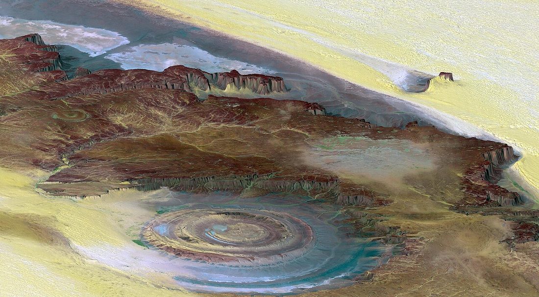
Richat Structure ("Eye of the Sahara", Mauritania)

Richat Structure ("Eye of the Sahara", Mauritania)
Image: NASA / JPL / NIMA, Wikimedia Commons, Public domain. Resized; not otherwise altered. All credits.
📍 Where It Is Adrar Plateau, Mauritania (North & West Africa) 21.1240°, -11.4020°
🏛️ Mainstream Date ~98 million years ago (Cretaceous igneous dome) + Acheulean tools Excavated baseline
🧭 Leading Edge / Open Angle Proposed c. 9600 BCE physical match for Plato's Atlantis rings Debated or newly revised
🪨 Heaviest Stone & Quarry In-place quartzite ring ridges (Mohs 7, 40 km across) Compare all 64 sites →
30-SECOND TAKEAWAY

In Plain English — The 30-Second Takeaway

What It Is:

The Richat Structure, or 'Eye of the Sahara,' is a 25-mile-wide bullseye of concentric stone rings in the Adrar desert of Mauritania.

What Everyone Agrees On (Measured Facts):

Hard quartzite rock rings span 40 km across. The igneous core dates to 98 million years ago, and Stone Age Acheulean hand-axes lie along its dry stream beds.

🏛️ Mainstream Archaeology View:

Geologists proved the concentric rings formed when a dome of sedimentary rock lifted up and eroded naturally, with zero ancient city walls found.

🧭 Leading Edge View:

Documentary researchers argue the inner rings (23.5 km or 14.6 miles wide), northern cliffs, and ancient river channels match Plato's account of Atlantis.

Site Story & Overview

The Richat Structure, widely known as the Eye of the Sahara, is a 40-kilometer-wide (25-mile) bullseye of concentric rock rings near Ouadane in central Mauritania. Early space crews used its striking rings as a landmark from orbit.

▸ Read Full Archaeological & Engineering Context

Geologists first wondered whether it was a giant meteorite crater. However, detailed mapping, drill cores, and radiometric dating by Guillaume Matton and Michel Jébrak (2005, 2014) showed it is a lifted dome of ancient sedimentary rock over a 98-million-year-old magma intrusion. Since 2011, documentary filmmakers and separate researchers have argued that its inner ring diameter (~23.5 km or 14.6 miles), northern cliff shelter, and southern paleoriver drainage match the layout of Atlantis in Plato's Critias.

✓ What Is Physically Measured on Site

Dated samples, laser scans, stone weights, and dug finds kept separate from opinion.

🏛️ Mainstream Archaeological View

  • Accepted timeline: Deeply eroded Cretaceous alkaline igneous dome (~98 million years old) formed by underground magma uplift and limestone karst dissolution, with Lower Paleolithic (Acheulean) stone tools and Neolithic campsites along its dry riverbeds.
  • Stone & hardness: Proterozoic–Ordovician quartzite cuestas, limestone, gabbro dikes & hydrothermal breccia — Mohs hardness 7.0 (Ordovician quartzite rings) (on the 1–10 Mohs scale where a steel knife is ~5.5 and diamond is 10).
  • Quarry distance & alignment: Stone source In situ eroded Cretaceous igneous dome (0 km). Orientation: Concentric circular rings (~23.5 km inner rings) opening south toward Tamanrasset paleoriver.

🧭 Leading Edge Proposal & Open Questions

  • Documentary researchers (George 2018; Bright Insight; visiting teams): Plato's Atlantis physical match: Propose that the Richat Structure matches Plato's Critias description of concentric rings of land and water (~23.5 km / 14.6 mi central rings), sheltered by northern mountains and draining south into the Tamanrasset paleoriver basin during the African Humid Period and Younger Dryas (~9600 BCE). [6][4][5]

Tested Claims About Richat Structure ("Eye of the Sahara", Mauritania)

ClaimStatusVerdict
An advanced civilisation existed during the last Ice Age and was lost in a catastrophe
Did an advanced seafaring culture exist during the Ice Age before floods and impacts destroyed it 12,000 years ago?
Leading EdgeOpen question
The Richat Structure ('Eye of the Sahara') in Mauritania is the physical site of Plato's Atlantis
Is the 25-mile-wide 'Eye of the Sahara' in Mauritania the physical location of Plato's lost capital of Atlantis?
Leading EdgeOpen question on literary inspiration; measured geology confirms a 98-million-year eroded igneous dome with Paleolithic/Neolithic stone tools and no Bronze Age urban architecture found to date

Visiting & base stays: Richat Structure ('Eye of the Sahara') & Ouadane / Chinguetti Oasis (Adrar Region, Mauritania)

Logistics & travel advisory note: Check current US State Department and UK FCDO travel advisories for Mauritania's Adrar region before travelling. Reaching the Richat Structure requires a 4x4 desert convoy with a local guide from Atar or Ouadane.

FTC affiliate disclosure: Tour links go to GetYourGuide and Viator. Hotel links use Stay22 (aid=solarevidence) for Booking.com and Expedia. If you book a trip, we may earn a small fee at no extra cost to you. All partner links use rel="sponsored nofollow noopener". Check travel alerts before you go. Partner fees never change our ratings. All 64 site field visits · Affiliate disclosure.

📚 Further Reading: Both Sides of the Argument

Top books from both sides of the debate on this topic. Browse all 34 books on Books & Further Reading or visit our Search for the Truth Bookshop.org storefront.

Mainstream Baseline 1998 ★ 4.4/5

Noah's Flood: The New Scientific Discoveries About the Event That Changed History

William Ryan & Walter Pitman

Two ocean geologists share seabed cores showing the Black Sea flooded rapidly around 5600 BCE.

▸ Why this book matters to both sides

Two Columbia University marine geologists present seabed cores, drowned shorelines, and sonar profiles for a rapid flooding of the freshwater Black Sea basin around 5600 BCE.

Role in the debate: Demonstrates how marine geologists test whether ancient Near Eastern deluge traditions preserve a real Holocene coastal inundation. (ISBN 9780684859200)

Mainstream Baseline 2004 ★ 4.4/5

The Long Summer: How Climate Changed Civilization

Brian Fagan

Explains how sudden climate flips—like the 1,200-year Younger Dryas freeze—shaped early human farming and towns.

▸ Why this book matters to both sides

Archaeologist Brian Fagan examines how the Younger Dryas cold reversal, Lake Agassiz meltwater releases, the 8.2 ka event, and mid-Holocene droughts shaped agriculture and ancient states.

Role in the debate: Sets out the standard ocean-circulation (AMOC shutdown) and ancient climate model of the Younger Dryas and its effects on Near Eastern and European societies. (ISBN 9780465022823)

Bridge / Debate History 2010 ★ 4.5/5

Atlantis and the Cycles of Time: Prophecies, Traditions, and Occult Revelations

Joscelyn Godwin

Traces two centuries of books and debates about Atlantis, pole shifts, Edgar Cayce, and repeating world ages.

▸ Why this book matters to both sides

Colgate University intellectual historian Joscelyn Godwin traces two centuries of geological, rationalist, and esoteric theories about Atlantis, Edgar Cayce, Bimini, pole shifts, and world-age cycles.

Role in the debate: Maps out exactly where modern ideas about lost continents, Hall of Records traditions, and cyclical disasters originated in 19th- and 20th-century thought. (ISBN 9781594772627)

Leading Edge 2015 ★ 4.7/5

Magicians of the Gods: The Forgotten Wisdom of Earth's Lost Civilization

Graham Hancock

Links Göbekli Tepe, Baalbek, and the Younger Dryas comet debate to argue a cosmic impact erased an Ice Age world.

▸ Why this book matters to both sides

Integrates Göbekli Tepe, Baalbek, Gunung Padang. The Younger Dryas comet-impact idea. It argues Taurid meteor-stream impacts between 12,800 and 11,600 years ago erased an advanced culture.

Role in the debate: Sets out the strongest popular overview linking Göbekli Tepe's enclosures and Pillar 43 to the Younger Dryas impact debate. (ISBN 9781250118400)

FTC affiliate disclosure: Book links go to Bookshop.org (ID 130218, Search for the Truth). Each sale helps local bookstores and pays us a 10% fee at no extra cost to you. All partner links use rel="sponsored nofollow noopener". Fees never change our verdicts. Affiliate disclosure.

Primary Academic Sources

▸ View All Cited Primary Sources & DOIs (6 papers)
  1. Matton, G., Jébrak, M. & Lee, J. K. W. (2005). Resolving the Richat enigma: Doming and hydrothermal karstification above an alkaline complex. Geology 33(8): 665–668. doi:10.1130/G21542.1 data
  2. Matton, G. & Jébrak, M. (2014). The "Eye of Africa" (Richat dome, Mauritania): An isolated Cretaceous alkaline–hydrothermal complex. Journal of African Earth Sciences 97: 109–124. doi:10.1016/j.jafrearsci.2014.04.006 data
  3. Dietz, R. S., Fudali, R. & Cassidy, W. (1969). Richat and Semsiyat Domes (Mauritania): Not Astroblemes. Geological Society of America Bulletin 80(7): 1367–1372. doi:10.1130/0016-7606(1969)80[1367:rasdmn]2.0.co;2 critique
  4. Skonieczny, C., Paillou, P., Bory, A. et al. (2015). African humid periods triggered the reactivation of a large river system in Western Sahara (Tamanrasset paleoriver). Nature Communications 6: 8751. doi:10.1038/ncomms9751 data
  5. NASA Earth Observatory (2018). Richat Structure, Mauritania (geological overview and Acheulean artifact distribution along outer wadi beds). https://earthobservatory.nasa.gov/images/92071/richat-structure background
  6. Plato (c. 360 BCE). Critias (113c–118b, dimensions of the concentric rings and plain of Atlantis; English translation by W. R. M. Lamb, Perseus Digital Library). https://www.perseus.tufts.edu/hopper/text?doc=Plat.+Criti.+113c proponent

Dates and stone checks are summed up in plain English from the papers above. Measured facts stay separate from opinion. Methodology.