The Richat Structure ('Eye of the Sahara') in Mauritania is the physical site of Plato's Atlantis
Status: Leading EdgeVerdict: Open question on literary inspiration; measured geology confirms a 98-million-year eroded igneous dome with Paleolithic/Neolithic stone tools and no Bronze Age urban architecture found to date
30-SECOND TAKEAWAY
In Plain English — The 30-Second Takeaway
What It Is:
Is the 25-mile-wide 'Eye of the Sahara' in Mauritania the physical location of Plato's lost capital of Atlantis?
What Everyone Agrees On (Measured Facts):
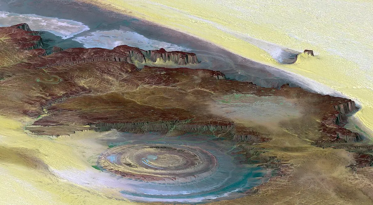
The Richat Structure has concentric stone rings spanning 40 km (25 miles) across. Its igneous center dates to 98 million years ago, and Stone Age tools lie in its dry riverbeds.
🏛️ Mainstream Archaeology View:
Geologists proved the concentric rings are a natural rock dome shaped by erosion. No Bronze Age city walls, pottery, or metal tools have ever been excavated there.
🧭 Leading Edge View:
Documentary researchers note that the inner rings measure 23.5 km (14.6 miles) wide, matching Plato's numbers, while ancient rivers drained south toward the Atlantic.
Overview & Context
In Timaeus and Critias (c. 360 BCE), the Athenian philosopher Plato described Atlantis as a naval metropolis built around three concentric rings of water and two of land totaling 127 stadia (~23.5 km or 14.6 miles) across, sheltered by mountains to the north and opening southward toward a vast plain and the Atlantic Ocean, which flooded around 9,000 years before Solon's visit to Egypt (~9600 BCE).
▸ Read Technical Background, Full Claim Wording & Academic Literature History
Formal claim tested: The 40-kilometer-wide concentric rings of the Richat Structure in Mauritania physically match the dimensions, northern mountain shelter, and southern river drainage of the capital city of Atlantis described in Plato's Critias, dating to the Younger Dryas (~9600 BCE).
Where the evidence stands: Satellite radar and ancient climate studies confirm that the Western Sahara held large lake networks and the active Tamanrasset paleoriver during the African Humid Period, and the diameter of the Richat Structure's inner ring system (~23.5 km / 14.6 miles) is close to the 127 stadia (~23.5 km) given in Plato's Critias. However, geological mapping and 40Ar/39Ar dating (Matton et al. 2005, 2014) show that the concentric rings are natural Proterozoic–Ordovician quartzite ridges uplifted by a 98-million-year-old Cretaceous magma dome, and archaeological surveys have found only Acheulean stone hand-axes and Neolithic pastoralist artifacts—with zero walled cities, metallurgy, or canals dug to date.
Since 2011, separate researchers and documentary producers have argued that the Richat Structure ('Eye of the Sahara') in central Mauritania matches those geographic details during the Green Sahara phase. Geologists and archaeologists reply that the rings are tilted sedimentary strata eroded over 98 million years and that no Bronze Age or urban remains exist on site. See also the lost Ice Age civilization review and the Bimini Road review.
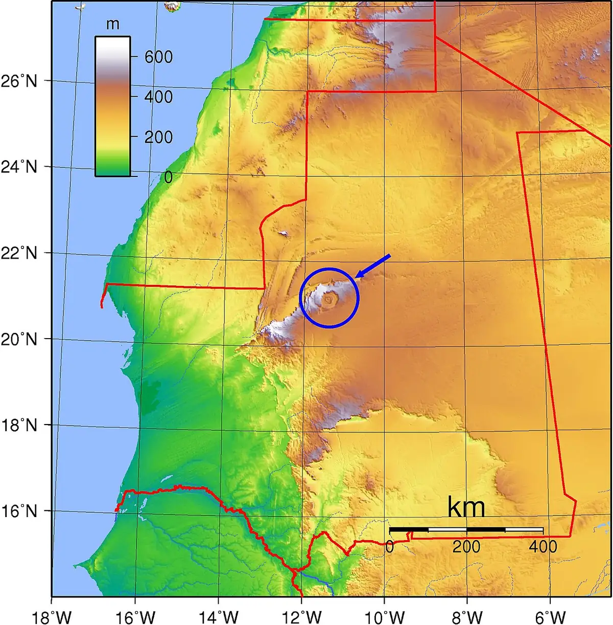
NASA Shuttle Radar Topography Mission view of the Richat Structure ('Eye of the Sahara'), showing its eroded concentric quartzite rings. Image: NASA / JPL / NIMA, Public domain, via Wikimedia Commons. Resized.Location of the Richat Structure on the Adrar Plateau of central Mauritania, north of the Tamanrasset paleoriver basin. Image: Bourrichon / Wikimedia Commons, Public domain, via Wikimedia Commons. Resized.
✓ What Has Been Physically Measured
Dates, physical measurements, and excavated findings kept separate from interpretation.
40-km dome and 23.5-km inner rings: The full Richat dome spans 40 km (25 miles) across in the Adrar Plateau (21.124°N, 11.402°W). Meanwhile, the prominent inner triple-ring complex measures roughly 20 to 23.5 km (12.4 to 14.6 miles) across—close to Plato's 127 Greek stadia (~23.5 km at 185 m per stadion). [1][2][6]
98-million-year Cretaceous uplift: Mapping, drill cores, and 40Ar/39Ar radiometric dating of gabbro ring dikes, carbonatites, and the central hydrothermal breccia body yield an age of ~98.2 ± 2.6 million years (Matton et al. 2005, 2014). The rings are natural differential erosion of hard quartzite cuestas (Mohs 7) and softer shale valleys. [1][2][3]
Active Tamanrasset paleoriver: Orbital radar imaging and marine sediment cores off Mauritania prove that the Tamanrasset paleoriver basin—south of the Adrar highlands—carried heavy freshwater runoff to the Atlantic Ocean during African Humid Periods (including after the Younger Dryas, c. 9500–3500 BCE). [4]
Acheulean and Neolithic artifact record: Field surveys along the Richat wadi beds have recorded abundant Lower Paleolithic Acheulean quartzite hand-axes and Neolithic stone projectile points and grinding stones, but zero dressed masonry walls, ceramics from an urban state, bronze weapons, or harbor works. [5][2]
🧭 Proponents' Case & Cited Evidence
Ring diameter and directional topography: Supporters point out that the inner concentric rings measure ~23.5 km across (matching 127 stadia), that the Adrar escarpment rises right north of the structure with freshwater springs, and that dry wadi channels breach the southern rim toward the Tamanrasset paleoriver plain. [6][4]
9600 BCE Green Sahara timing: Plato's date of 9,000 years before Solon (~9600 BCE) coincides closely with the end of the Younger Dryas (~9700 BCE), rapid Meltwater Pulse sea-level shifts, and the sudden onset of the African Humid Period across Mauritania. [6][4]
Herodotus's 'Atlantes' in northwest Africa: Supporters note that 5th-century BCE Greek historian Herodotus placed a tribe called the Atlantes and Mount Atlas in northwestern Africa, suggesting Egyptian or Greek travelers may have heard real accounts of a circular Saharan oasis basin. [6]
🏛️ Mainstream Archaeological View & Evidence
100% natural bedrock cuestas: Geologists Guillaume Matton and Michel Jébrak showed that the concentric rings are tilted Proterozoic–Ordovician rock layers cut by natural erosion over tens of millions of years, not artificial canals dug by human hands. [1][2]
400 Meters above sea level: The floor of the Richat Structure sits ~400 to 430 m (1,310 to 1,410 feet) above modern sea level and ~500 km (310 miles) inland from the Atlantic coast. By contrast, Plato described sea-going triremes sailing directly from the ocean into the rings of the city. [2][6]
Complete absence of urban archaeology: Despite decades of geological coring, surface walks, and satellite photography over open desert bedrock with minimal soil cover, no stone buildings, paved docks, metallurgy, or stratified city trash have ever been found inside the rings. [5][2]
🔬 What Future Tests Would Settle It
Optically stimulated luminescence (OSL) and carbon dating of sediment cores from the deepest seasonal lakebeds inside the Richat depressions would establish the exact water depths during the Younger Dryas and African Humid Period (~11,000–5,000 BCE). Only a stratified archaeological excavation uncovering dated buildings or metallurgy inside the rings would support an urban town claim.
Noah's Flood: The New Scientific Discoveries About the Event That Changed History
William Ryan & Walter Pitman
Two ocean geologists share seabed cores showing the Black Sea flooded rapidly around 5600 BCE.
▸ Why this book matters to both sides
Two Columbia University marine geologists present seabed cores, drowned shorelines, and sonar profiles for a rapid flooding of the freshwater Black Sea basin around 5600 BCE.
Role in the debate: Demonstrates how marine geologists test whether ancient Near Eastern deluge traditions preserve a real Holocene coastal inundation. (ISBN 9780684859200)
Explains how sudden climate flips—like the 1,200-year Younger Dryas freeze—shaped early human farming and towns.
▸ Why this book matters to both sides
Archaeologist Brian Fagan examines how the Younger Dryas cold reversal, Lake Agassiz meltwater releases, the 8.2 ka event, and mid-Holocene droughts shaped agriculture and ancient states.
Role in the debate: Sets out the standard ocean-circulation (AMOC shutdown) and ancient climate model of the Younger Dryas and its effects on Near Eastern and European societies. (ISBN 9780465022823)
Atlantis and the Cycles of Time: Prophecies, Traditions, and Occult Revelations
Joscelyn Godwin
Traces two centuries of books and debates about Atlantis, pole shifts, Edgar Cayce, and repeating world ages.
▸ Why this book matters to both sides
Colgate University intellectual historian Joscelyn Godwin traces two centuries of geological, rationalist, and esoteric theories about Atlantis, Edgar Cayce, Bimini, pole shifts, and world-age cycles.
Role in the debate: Maps out exactly where modern ideas about lost continents, Hall of Records traditions, and cyclical disasters originated in 19th- and 20th-century thought. (ISBN 9781594772627)
Magicians of the Gods: The Forgotten Wisdom of Earth's Lost Civilization
Graham Hancock
Links Göbekli Tepe, Baalbek, and the Younger Dryas comet debate to argue a cosmic impact erased an Ice Age world.
▸ Why this book matters to both sides
Integrates Göbekli Tepe, Baalbek, Gunung Padang. The Younger Dryas comet-impact idea. It argues Taurid meteor-stream impacts between 12,800 and 11,600 years ago erased an advanced culture.
Role in the debate: Sets out the strongest popular overview linking Göbekli Tepe's enclosures and Pillar 43 to the Younger Dryas impact debate. (ISBN 9781250118400)
FTC affiliate disclosure: Book links go to Bookshop.org (ID 130218, Search for the Truth). Each sale helps local bookstores and pays us a 10% fee at no extra cost to you. All partner links use rel="sponsored nofollow noopener". Fees never change our verdicts. Affiliate disclosure.
Visiting & base stays: Richat Structure ('Eye of the Sahara') & Ouadane / Chinguetti Oasis (Adrar Region, Mauritania)
Logistics & travel advisory note: Check current US State Department and UK FCDO travel advisories for Mauritania's Adrar region before travelling. Reaching the Richat Structure requires a 4x4 desert convoy with a local guide from Atar or Ouadane.
FTC affiliate disclosure: Tour links go to GetYourGuide and Viator. Hotel links use Stay22 (aid=solarevidence) for Booking.com and Expedia. If you book a trip, we may earn a small fee at no extra cost to you. All partner links use rel="sponsored nofollow noopener". Check travel alerts before you go. Partner fees never change our ratings. All 64 site field visits · Affiliate disclosure.
Primary Academic Sources
▸ View All Cited Primary Sources & DOIs (6 papers)
Matton, G., Jébrak, M. & Lee, J. K. W. (2005). Resolving the Richat enigma: Doming and hydrothermal karstification above an alkaline complex. Geology 33(8): 665–668. doi:10.1130/G21542.1data
Matton, G. & Jébrak, M. (2014). The "Eye of Africa" (Richat dome, Mauritania): An isolated Cretaceous alkaline–hydrothermal complex. Journal of African Earth Sciences 97: 109–124. doi:10.1016/j.jafrearsci.2014.04.006data
Dietz, R. S., Fudali, R. & Cassidy, W. (1969). Richat and Semsiyat Domes (Mauritania): Not Astroblemes. Geological Society of America Bulletin 80(7): 1367–1372. doi:10.1130/0016-7606(1969)80[1367:rasdmn]2.0.co;2critique
Skonieczny, C., Paillou, P., Bory, A. et al. (2015). African humid periods triggered the reactivation of a large river system in Western Sahara (Tamanrasset paleoriver). Nature Communications 6: 8751. doi:10.1038/ncomms9751data
Sources checked against Crossref and publisher pages on 2026-10-27. This entry presents a debated idea neutrally: the proponents' case first, then the mainstream position, in plain English. "Open question" is not a judgment that the idea is true or false. Labels describe the claim, not the people who hold it. Methodology.