The Bimini Road is a man-made structure, possibly linked to Atlantis
Status: Leading EdgeVerdict: Open question on origin; measured: cores and radiocarbon ages of about 2,200–3,500 years point to natural beachrock, and our sea-level check shows the site was dry land 10,000–12,000 years ago, 12–49 m or more above the sea
30-SECOND TAKEAWAY
In Plain English — The 30-Second Takeaway
What It Is:
Is the half-mile line of blocky stones underwater off Bimini in the Bahamas a sunken road or natural beach rock?
What Everyone Agrees On (Measured Facts):
Rock cores date to 2,200–3,500 years ago with continuous sand layers across blocks. Our sea-level check shows it was dry land 10,000 years ago.
🏛️ Mainstream Archaeology View:
Marine geologists conclude the Bimini Road is natural beachrock that cemented 3,000 years ago and cracked into neat blocks.
🧭 Leading Edge View:
Divers report small wedge stones under the main blocks and argue it was built as a harbour wall when sea level was lower.
Overview & Context
The Bimini Road is a slightly curved line of limestone blocks about 0.8 km long, in about 5–6 m of water off North Bimini, with two shorter parallel lines beside it. The largest blocks are 3–4 m across.
▸ Read Technical Background, Full Claim Wording & Academic Literature History
Formal claim tested: The line of large, roughly rectangular stone blocks in shallow water off North Bimini, Bahamas, found in 1968, is a man-made road, wall or harbour breakwater, possibly from a culture flooded at the end of the Ice Age.
Where the evidence stands: The geology is well sampled. Cores, bedding that runs nonstop from block to block, and carbon ages of about 2,200–3,500 years fit beachrock that cracked in place, and Gifford and Ball found no second course of blocks and no tool marks. Leading Edge researchers (Zink in the 1970s, Little in 2005–2006) report stones under and between the blocks that they read as shims, stacked courses and worked surfaces, and interpret the feature as an ancient breakwater. Those findings are published by their authors and have not been separately tested. Our own check of a coral sea-level record shows the site was dry land 10,000–12,000 years ago. That is open to either reading: it rules out an underwater structure at that time, but not one built on dry land and later drowned, which no dated find has yet shown.
It became famous because Edgar Cayce had said in 1940 that part of Atlantis would "rise again" in 1968 or 1969. The find came in September 1968. Since then geologists have cored and dated it, and Leading Edge researchers have dived it repeatedly. Related: the lost Ice Age civilisation claim, the Yonaguni claim and the scale-gap and transport review.
Computation & method notes: We took every Acropora palmata sample in the Peltier & Fairbanks (2006) Barbados record, which is already corrected for Barbados uplift. This coral lives in the top ~5 m of water, so sea level at each date was no higher than the coral depth plus 5 m. We compared that upper bound with the Road's depth of 4.6–5.5 m. Assumption: Bimini and Barbados had similar relative sea level once uplift is removed. Differences in glacial rebound across the region are a few metres, small next to the 12–49 m margins. Script: bimini-sea-level.py.
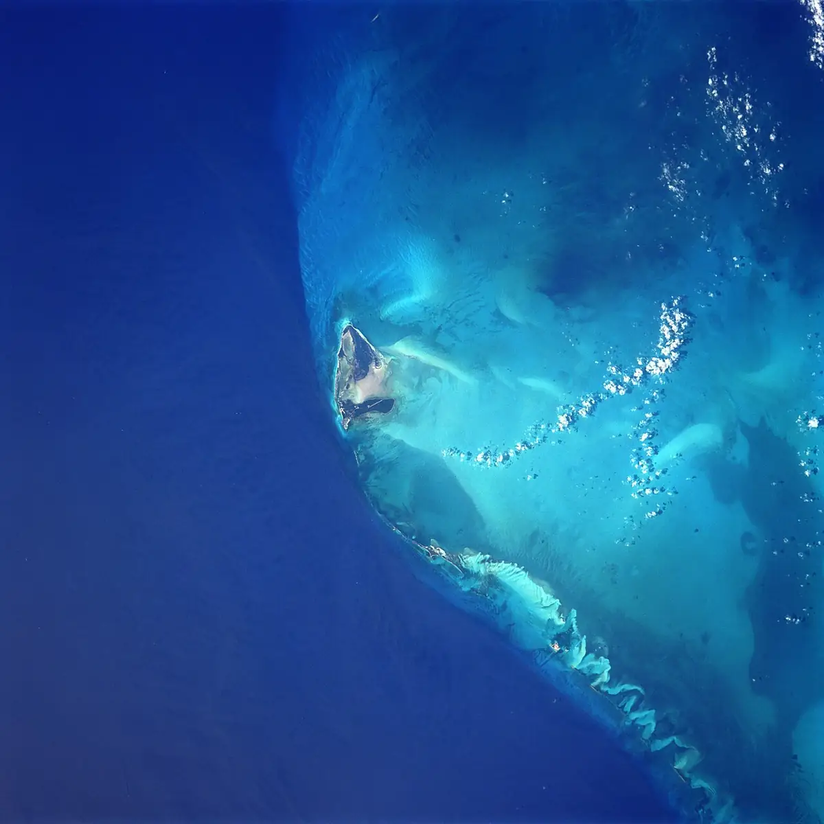
The Bimini islands from space (NASA). The Bimini Road lies in shallow water off North Bimini. No openly licensed underwater photo was found. Image: NASA (Space Shuttle STS-91 crew photograph), Public domain, via Wikimedia Commons. Resized.
✓ What Has Been Physically Measured
Dates, physical measurements, and excavated findings kept separate from interpretation.
Discovery: On 2 September 1968, Joseph Manson Valentine, Jacques Mayol and Robert Angove dived on a "pavement" of stones in about 5.5 m of water off North Bimini. Dimitri Rebikoff, often named as a discoverer, joined later expeditions and published a precision photomosaic of the feature in 1972. [1][2]
Single-layer coquina beachrock: Harrison (1971) described the blocks as coquina beachrock whose margins match their neighbours, with no blocks resting on a second set. [3]
2,200–3,500 BP carbon dates: Carbon dates on cores taken about 4.6 m below sea level (Calvert et al. 1979): whole rock 2,780 ± 70, 3,500 ± 80 and 3,350 ± 90 years BP. Shell 3,510 ± 70 BP. Cement 2,770 ± 80 and 2,840 ± 70 BP. McKusick and Shinn (1980) report an age of about 2,200 ± 150 years and interpret the blocks as natural beachrock. [4][5][1]
17 oriented USGS drill cores: Shinn's USGS team took 17 oriented cores in the mid-1970s: the internal layers dip consistently toward deep water and pebble layers can be traced from one stone into the next, as expected if a single sheet of rock cracked in place. Conch-shell ages of 2,000–4,000 years are maximum ages for the rock. [6]
4-meter blocks & Florida match: Shinn (2009) reports blocks up to 4 m across in 5–7 m of water, and similar fractured-beachrock blocks about 90 m deep off south-west Florida, which no one regards as man-made. [7]
Bedrock uranium-thorium date: Gifford and Ball (1980) found no second course of blocks anywhere, no tool marks, and internal features continuous across blocks for only about 50 m. Their uranium–thorium date of 14,992 ± 258 years came from partly recrystallised limestone below the beachrock, not from the blocks. [1]
Barbados coral sea-level check: Our sea-level check (Barbados Acropora palmata corals, which grow within about 5 m of the surface): between 8,500 and 12,500 years ago the sea stood at least about 20 to 53 m below today. The top of the Road (−4.6 m) was therefore dry land, at least 12 m above the sea at 9,500–10,500 years ago, 32 m at 10,500–11,500 and 49 m at 11,500–12,500. At the time of Gifford and Ball's 15,000-year date the sea was about 95–100 m lower, so that date cannot be the age of a marine rock at this depth. [9][10][11][12]
Cayce context: In reading 958-3 (28 June 1940), Edgar Cayce said that "Poseidia will be among the first portions of Atlantis to rise again. Expect it in sixty-eight and sixty-nine". The 1968 find was promoted as a fulfilment, and people associated with the Cayce group took part in later expeditions. [13][1]
David Zink's dive surveys: David Zink (The Stones of Atlantis, 1978) led several expeditions and read the feature as built by people. He also reported that most blocks rest on bedrock or on smaller stones. [14][1]
Reported shims and anchors: Greg Little and colleagues (2005–2006 dives) report flat, cut-looking slabs about 60 × 38 × 15 cm and wedge-shaped stones under the large blocks, which they read as levelling shims, as well as places where blocks lie stacked and surfaces they describe as tool-marked. They also report stone anchors at a nearby site and interpret the Road as an ancient harbour breakwater. [15][16]
🏛️ Mainstream Archaeological View & Evidence
Young shoreline beachrock age: The block material is beachrock, which forms at the shoreline. Its dates (about 2,200–3,500 years) are far younger than the end of the Ice Age, and bedding runs nonstop from block to block, as in a single cracked layer. [6][4][5]
Bahamian limestone cementation: Strasser and Davaud (1986) describe how Holocene limestone sequences in the Bahamas form through the build-out, cementation and erosion of beach and shoreline deposits. [8]
Gifford and Ball found: no second course of blocks, and modern sampling and souvenir collecting leave fresh marks on the blocks, so tool marks seen today are hard to date. [1]
Natural Florida beachrock parallels: Identical fractured beachrock occurs elsewhere, including about 90 m deep off Florida. [7]
🔬 What Future Tests Would Settle It
Carbon or luminescence dates on the slabs and wedge stones that Little reports under the blocks would help. So would a separate, published microscopic study of the claimed tool marks compared with recent sampling scars. The bedding angle of any stacked blocks: a placed block should not continue the layering of the one below. Any dated artefact sealed beneath a block would also be informative.
Noah's Flood: The New Scientific Discoveries About the Event That Changed History
William Ryan & Walter Pitman
Two ocean geologists share seabed cores showing the Black Sea flooded rapidly around 5600 BCE.
▸ Why this book matters to both sides
Two Columbia University marine geologists present seabed cores, drowned shorelines, and sonar profiles for a rapid flooding of the freshwater Black Sea basin around 5600 BCE.
Role in the debate: Demonstrates how marine geologists test whether ancient Near Eastern deluge traditions preserve a real Holocene coastal inundation. (ISBN 9780684859200)
Atlantis and the Cycles of Time: Prophecies, Traditions, and Occult Revelations
Joscelyn Godwin
Traces two centuries of books and debates about Atlantis, pole shifts, Edgar Cayce, and repeating world ages.
▸ Why this book matters to both sides
Colgate University intellectual historian Joscelyn Godwin traces two centuries of geological, rationalist, and esoteric theories about Atlantis, Edgar Cayce, Bimini, pole shifts, and world-age cycles.
Role in the debate: Maps out exactly where modern ideas about lost continents, Hall of Records traditions, and cyclical disasters originated in 19th- and 20th-century thought. (ISBN 9781594772627)
Underworld: The Mysterious Origins of Civilization
Graham Hancock
Combines Ice Age sea-level flood maps with scuba dives at submerged ruins off India, Japan, Malta, and Bimini.
▸ Why this book matters to both sides
Combines Glenn Milne's post-glacial sea-level inundation maps with scuba studies at India's Gulf of Khambhat and Dwarka, Japan's Yonaguni terraces, Malta, and Bimini.
Role in the debate: Frames the submerged-shelf debate over whether features at Yonaguni, Dwarka, and Bimini are human-modified monuments drowned by Meltwater pulses or natural coastal geology. (ISBN 9781400049516)
Maps of the Ancient Sea Kings: Evidence of Advanced Civilization in the Ice Age
Charles H. Hapgood
Studies the 1513 Piri Reis map and old sea charts to argue they copy surveys made by Ice Age mariners.
▸ Why this book matters to both sides
Analyzes the 1513 Piri Reis map, the 1531 Oronteus Finaeus map, and medieval portolans with U.S. Air Force cartographers. It argues they preserve spherical trigonometrical surveys from an Ice Age seafaring culture.
Role in the debate: A foundational source for the lost-Ice-Age-culture and Antarctica cartography arguments cited by Hancock, Flem-Ath, and Schoch. (ISBN 9780932813428)
FTC affiliate disclosure: Book links go to Bookshop.org (ID 130218, Search for the Truth). Each sale helps local bookstores and pays us a 10% fee at no extra cost to you. All partner links use rel="sponsored nofollow noopener". Fees never change our verdicts. Affiliate disclosure.
Visiting & base stays: Bimini Road (Prospector's Ledge) & Bahamas Carbonate Platform (North Bimini / Nassau base)
FTC affiliate disclosure: Tour links go to GetYourGuide and Viator. Hotel links use Stay22 (aid=solarevidence) for Booking.com and Expedia. If you book a trip, we may earn a small fee at no extra cost to you. All partner links use rel="sponsored nofollow noopener". Check travel alerts before you go. Partner fees never change our ratings. All 64 site field visits · Affiliate disclosure.
Primary Academic Sources
▸ View All Cited Primary Sources & DOIs (16 papers)
Wikipedia. Bimini Road (secondary summary, including the 1968 discovery and Gifford and Ball's 1980 observations, which are not online). https://en.wikipedia.org/wiki/Bimini_Roadbackground
Rebikoff, D. (1972). Precision underwater photomosaic techniques for archaeological mapping: interim experiment on the Bimini "Cyclopean" complex. International Journal of Nautical Archaeology 1. doi:10.1111/j.1095-9270.1972.tb00696.xdata
Calvert, P. M., Introne, D. S. & Stipp, J. J. (1979). University of Miami radiocarbon dates XIV. Radiocarbon 21 (Bimini Road core dates). doi:10.1017/s0033822200004239data
McKusick, M. & Shinn, E. A. (1980). Bahamian Atlantis reconsidered. Nature 287: 11–12. doi:10.1038/287011a0data
Shinn, E. A. (2009). The mystique of beachrock. In Swart, P. K. et al. (eds), Perspectives in Carbonate Geology. IAS Special Publication 41: 19–28. doi:10.1002/9781444312065.ch2data
Strasser, A. & Davaud, E. (1986). Formation of Holocene limestone sequences by progradation, cementation, and erosion: two examples from the Bahamas. Journal of Sedimentary Research 56. doi:10.1306/212f8936-2b24-11d7-8648000102c1865ddata
Truth in Stone (2026). Bimini Road sea-level check from the Barbados coral record: Python script, released under CC0 1.0. /static/downloads/bimini-sea-level.pydata
Peltier, W. R. & Fairbanks, R. G. (2006). Global glacial ice volume and Last Glacial Maximum duration from an extended Barbados sea level record. Quaternary Science Reviews 25. doi:10.1016/j.quascirev.2006.04.010data
Lambeck, K. et al. (2014). Sea level and global ice volumes from the Last Glacial Maximum to the Holocene. PNAS 111. doi:10.1073/pnas.1411762111data
Edgar Cayce reading 958-3 (28 June 1940), transcript ("Poseidia will be among the first portions of Atlantis to rise again. Expect it in sixty-eight and sixty-nine"). https://archive.edgarcayce.ch/Reading%200958-0003.htmlproponent
Little, G. (2006). New underwater Bimini find: report on the June 2006 Bimini expedition (wedge stones, slabs under the blocks, stone anchors; self-published). https://www.mysterious-america.com/newunderwaterbim.htmlproponent
Sources checked against Crossref and publisher pages on 2026-10-23. This entry presents a debated idea neutrally: the proponents' case first, then the mainstream position, in plain English. "Open question" is not a judgment that the idea is true or false. Labels describe the claim, not the people who hold it. Methodology.