△ TruthInStone

Sites › Asia › Sigiriya, Anuradhapura (Jetavanaramaya) and Polonnaruwa

Sigiriya, Anuradhapura (Jetavanaramaya) and Polonnaruwa

Sigiriya, Anuradhapura (Jetavanaramaya) and Polonnaruwa
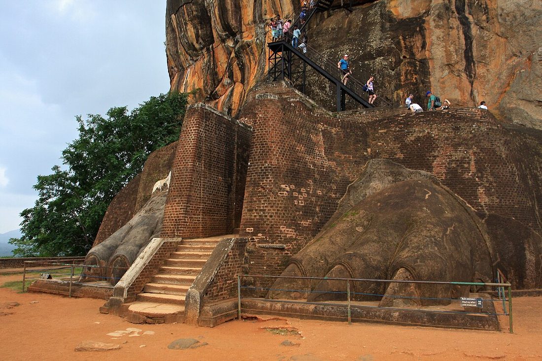
Image: TravelingOtter, Wikimedia Commons, CC BY-SA 2.0. Resized; not otherwise altered. All credits.
📍 Where It Is Matale, Anuradhapura & Polonnaruwa, Cultural Triangle, Sri Lanka 7.9570°, 80.7603°
🏛️ Mainstream Date Anuradhapura c. 300 BCE–1000 CE · Sigiriya c. 477–495 CE Excavated baseline
🧭 Leading Edge / Open Angle 122-m Jetavanaramaya was the 3rd-tallest building of antiquity after Giza Debated or newly revised
🪨 Heaviest Stone & Quarry 25 tons (Polonnaruwa 'Stone Book' hauled 90 km) · 93M bricks in 122-m stupa 0.6× the 40-ton test limit · Compare all 64 sites →
30-SECOND TAKEAWAY

In Plain English — The 30-Second Takeaway

What It Is:

Sri Lanka's Cultural Triangle links the 180-meter rock fortress of Sigiriya with the giant brick pyramid-stupas of Anuradhapura. Also, the granite monoliths of Polonnaruwa.

What Everyone Agrees On (Measured Facts):

Built around 300 CE, Anuradhapura's Jetavanaramaya stupa stood 122 meters. (400 feet) tall. Third in the ancient world only to the two largest Giza pyramids. Also, Polonnaruwa's 25-ton granite 'Stone Book' was hauled 90 km.

🏛️ Mainstream Archaeology View:

Scholars document an island-wide hydraulic system of giant artificial lakes, granite pressure-relief valves. 5th-century gravity fountains at Sigiriya that still spray water today.

🧭 Leading Edge View:

Experts highlight that Sri Lankan engineers built 400-foot sites. It also hauled 25-ton granite slabs 90 km over land.

Site Story & Overview

Sri Lanka's Cultural Triangle pairs colossal brick stupas on a scale rivaling Egypt's pyramids with precision gneiss and granite stonework and basin-wide hydraulic building. At Anuradhapura, the Jetavanaramaya and Abhayagiri stupas stood over 100–120 m tall in the 3rd–4th centuries CE, supported by an island-wide cascade of artificial reservoirs (wewas) and granite-lined sluice valves (bisokotuwa) that regulated water pressure beneath high earthen dams. Sixty km south, Sigiriya integrates a 180 m granite-gneiss monolith with axial water gardens, mirror-polished lime-plaster gallery walls (the 'Mirror Wall'), and gravity-fed fountains.

✓ What Is Physically Measured on Site

Dated samples, laser scans, stone weights, and dug finds kept separate from opinion.

🏛️ Mainstream Archaeological View

  • Accepted timeline: Anuradhapura served as Sri Lanka's capital from the 4th century BCE to the 11th century CE (Jetavanaramaya stupa built c. 276–303 CE under King Mahasena). Sigiriya's sky palace and hydraulic gardens were built under King Kashyapa I (477–495 CE), over a rock-shelter monastery occupied since the 3rd century BCE. Polonnaruwa flourished in the 11th–13th centuries CE.
  • Stone & hardness: Precambrian charnockitic gneiss, biotite granite & kiln-fired brick — Mohs hardness 6.5 (Charnockitic gneiss / Granite) (on the 1–10 Mohs scale where a steel knife is ~5.5 and diamond is 10).
  • Quarry distance & alignment: Stone source In situ gneiss at Sigiriya; ~90 km from Mihintale to Polonnaruwa (25 t Galpota slab). Orientation: Strict cardinal East–West water-garden & stupa axes.

🧭 Leading Edge Proposal & Open Questions

  • Hydraulic & megalithic engineering studies: Highlight that Anuradhapura's Jetavanaramaya (originally 122 m / 400 ft tall) was the third-tallest built monument in the ancient world after the two largest Giza pyramids, and that Sigiriya's 5th-century pressure fountains still operate by gravity alone after 1,500 years [1][2]

Tested Claims About Sigiriya, Anuradhapura (Jetavanaramaya) and Polonnaruwa

ClaimStatusVerdict
How the world's megaliths were moved: what is shown, what is inferred, and where the gaps are
Can wooden sledges, ropes, wet sand, and dirt ramps explain how ancient crews moved stones weighing 80 to 860 tons?
ContestedMeasured in part: sledges, wetted or timber tracks, ramps and boats are documented, and finished monuments show ancient moves of about 750–860 t; no test of ancient methods we found goes above about 40 t, and the 1,000 t-plus Baalbek blocks never left the quarry
Precision and shaping in ancient stonework: what has been measured, what has been replicated
Did tight stone joints, flat granite boxes, drill cores, and stone vases require advanced machine tools?
Leading EdgeMeasured in part: tolerances of about 0.25–0.5 mm (Giza casing) and ±1–2 mm survey precision (Tiwanaku) are documented; copper-and-sand and hammerstone methods are replicated at small scale; how the sharpest interior angles, Petrie's spiral-grooved core and the finest vessels were finished is an open question

Visiting & base stays: Sigiriya Lion Rock, Anuradhapura Stupas & Polonnaruwa (Cultural Triangle, Sri Lanka)

FTC affiliate disclosure: Tour links go to GetYourGuide and Viator. Hotel links use Stay22 (aid=solarevidence) for Booking.com and Expedia. If you book a trip, we may earn a small fee at no extra cost to you. All partner links use rel="sponsored nofollow noopener". Check travel alerts before you go. Partner fees never change our ratings. All 64 site field visits · Affiliate disclosure.

📚 Further Reading: Both Sides of the Argument

Top books from both sides of the debate on this topic. Browse all 34 books on Books & Further Reading or visit our Search for the Truth Bookshop.org storefront.

Mainstream Baseline 2019 ★ 4.4/5 · AIA Holton Award

Archaeology from Space: How the Future Shapes Our Past

Sarah Parcak

Explains how satellites and airplane lasers spot buried cities, roads, and temples across Egypt and the Americas.

▸ Why this book matters to both sides

Remote-sensing archaeologist Sarah Parcak explains how multispectral satellite imagery and airborne LiDAR reveal buried towns, road networks, and giant foundations across Egypt, Europe, and the Americas.

Role in the debate: Explains the physics and ground-truthing requirements of remote sensing—essential context for comparing verified LiDAR cities against disputed subsurface radar claims. (ISBN 9781250231345)

Mainstream Baseline 2003 ★ 4.5/5

After the Ice: A Global Human History, 20,000–5000 BC

Steven Mithen

Follows human life across every continent from the peak of the Ice Age (20,000 BCE) to early farming towns (5000 BCE).

▸ Why this book matters to both sides

A continent-by-continent narrative of human life from the Last Glacial Maximum to 5000 BCE, built directly from excavation reports across the Near East (including Göbekli Tepe), Europe, Asia, and the Americas.

Role in the debate: Provides the archaeological baseline for what human populations were building, hunting, and cultivating before, during, and right after the Younger Dryas. (ISBN 9780674019997)

Leading Edge 2010 ★ 4.7/5

Lost Technologies of Ancient Egypt: Advanced Engineering in the Temples of the Pharaohs

Christopher Dunn

An engineer measures Egyptian granite boxes, statues, and drill cores with precision gauges to argue for advanced ancient tools.

▸ Why this book matters to both sides

Manufacturing engineer Christopher Dunn applies straightedges, radius gauges, and optical comparators to the Serapeum granite sarcophagi, Luxor Ramses statues, and Petrie's drill cores. It argues for high-speed mechanical tooling.

Role in the debate: Provides the primary Leading Edge metrology claims on Egyptian granite symmetry and flatness, contrasted on our precision pages with test copper-saw, tubular-drill, and pounder replications. (ISBN 9781591431022)

Leading Edge 2002 ★ 4.6/5

Underworld: The Mysterious Origins of Civilization

Graham Hancock

Combines Ice Age sea-level flood maps with scuba dives at submerged ruins off India, Japan, Malta, and Bimini.

▸ Why this book matters to both sides

Combines Glenn Milne's post-glacial sea-level inundation maps with scuba studies at India's Gulf of Khambhat and Dwarka, Japan's Yonaguni terraces, Malta, and Bimini.

Role in the debate: Frames the submerged-shelf debate over whether features at Yonaguni, Dwarka, and Bimini are human-modified monuments drowned by Meltwater pulses or natural coastal geology. (ISBN 9781400049516)

FTC affiliate disclosure: Book links go to Bookshop.org (ID 130218, Search for the Truth). Each sale helps local bookstores and pays us a 10% fee at no extra cost to you. All partner links use rel="sponsored nofollow noopener". Fees never change our verdicts. Affiliate disclosure.

Primary Academic Sources

▸ View All Cited Primary Sources & DOIs (4 papers)
  1. Bandaranayake, S. (1984). Sigiriya Project: First Archaeological Excavation and Research Report (January–September 1982). Colombo: Central Cultural Fund. https://openlibrary.org/works/OL2286614W data
  2. Coningham, R. A. E. et al. (2013). The Anuradhapura (Sri Lanka) Project: Vol. 3, The Hinterland. BAR International Series 2567. doi:10.30861/9781407311876 data
  3. UNESCO World Heritage Centre: Ancient City of Sigiriya (inscribed 1982). https://whc.unesco.org/en/list/202/ background
  4. UNESCO World Heritage Centre: Sacred City of Anuradhapura (inscribed 1982). https://whc.unesco.org/en/list/200/ background

Dates and stone checks are summed up in plain English from the papers above. Measured facts stay separate from opinion. Methodology.